High Atlas Scenic Passes: Four Routes to Plan Safely
Explore four High Atlas route ideas with practical notes on paved main roads, rougher side tracks, vehicle suitability, and official sources for checking road and weather conditions before departure.
The Engineering Feat: Driving the Backbone of Morocco
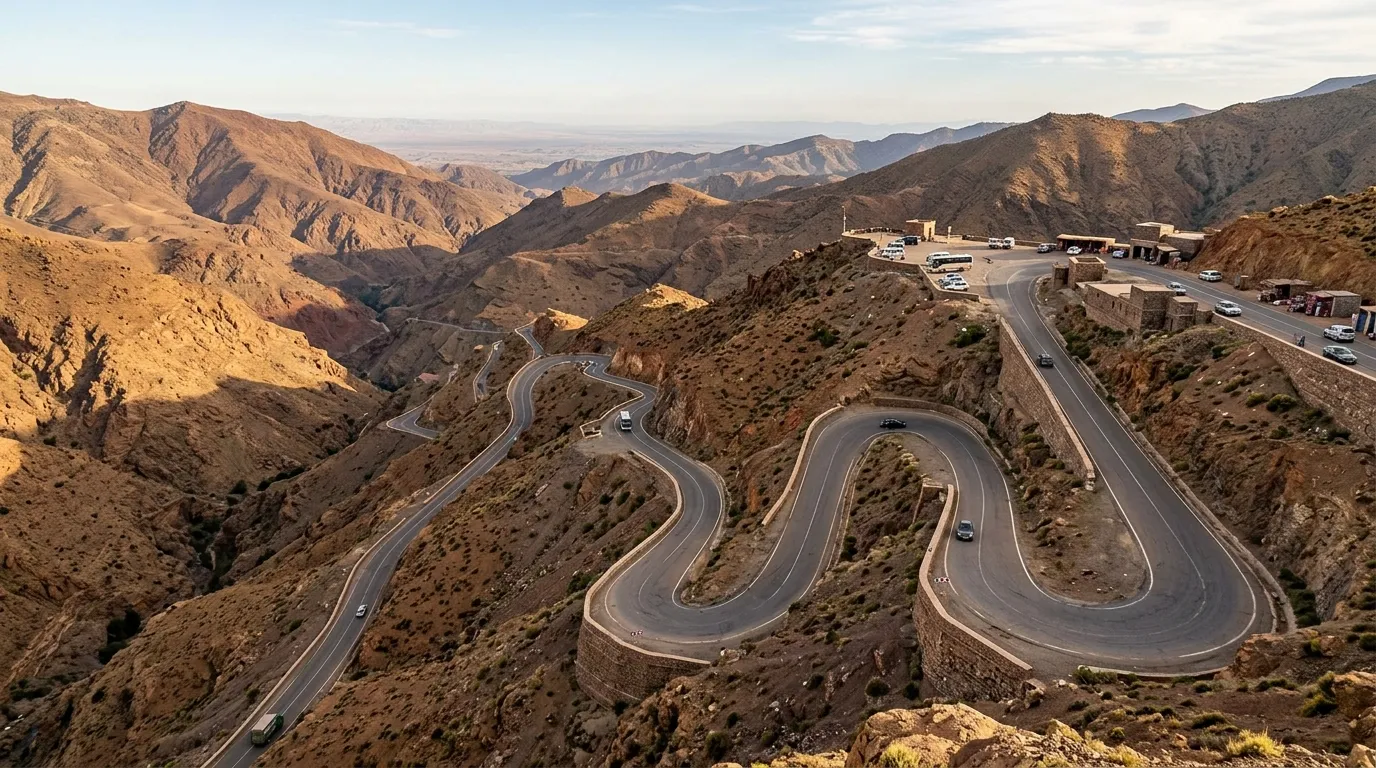
Climbing the slopes of the High Atlas is an intoxicating sensory transition. The humid plains of Marrakech drop away behind you as the scent of baking dust gives way to resinous mountain juniper and the clean, mineral chill of alpine air. The guttural roar of heavy diesel lorries reverberates off vertical red schist canyon walls, while down in the river clefts, vivid green walnut orchards and date palms flourish beneath ancient fortified earthen kasbahs.
Mountain roads need attention to traffic, visibility, and changing conditions. Check official alerts before setting out and follow signs and local authorities.
Fuel & Route Planning
Plan refuelling stops for the route you intend to drive and check opening hours and payment methods with stations or your rental provider. Availability can change; do not rely on unverified claims about a station or fixed fuel-reserve rule. Leave flexibility to refuel before remote sections.
Steep Descents
On mountain descents, obey posted signs, leave room for other traffic, and drive at a speed appropriate to visibility and the road. Follow the vehicle manual and rental provider guidance; do not rely on generic gear-selection instructions. If braking feels or smells abnormal, stop somewhere safe and contact roadside assistance rather than continuing. For motorway sections only, see ADM’s published safety reminders.
Paved Roads & Rough Tracks
The main N9 route over Tizi n’Tichka is a paved national road; a 4WD is not a blanket requirement for that corridor in ordinary conditions. Unsealed side tracks and remote connectors are different routes: check the surface, access, rental permissions, and current conditions before choosing them. A higher-clearance vehicle may help on rough ground but cannot make a closed or unsafe route suitable.
Check official road and weather information
These routes are planning ideas, not live road-status reports. Verify the exact road and travel date before departure.
- Ministry of Equipment / CNER Inforoute: official road incidents, closures, and winter service information where available. The portal or its data service may be unavailable; if so, confirm with local authorities.
- Morocco DGM weather-vigilance maps: check alerts for rain, thunderstorms, snow, wind, heat, and cold along the route.
- ADM Trafic: real-time incidents and roadworks on the motorway network only; it does not report every national or regional mountain road.
Safer mountain driving: wear seat belts, keep attention on the road, leave enough space, and adapt speed to signs, visibility, traffic, and surface. Avoid overtaking where sightlines are limited. Do not enter floodwater, a closed road, or an unsigned/unsafe diversion. For descents or warning signs, follow the vehicle manual and rental provider instructions; stop safely and seek assistance if the car behaves unusually. Recheck conditions if weather changes.
Explore the High Atlas routes from above
Select a corridor to trace its road alignment and open the matching route notes. Satellite imagery provides terrain context; it does not confirm current road access or safety.
Road alignments are planning representations derived from mapped road geometry and may differ from your chosen itinerary. They do not show live closures. Data and imagery credits appear on the map.
Logistical Matrix: Four High Atlas Mountain Crossings
Compare the main road surfaces, vehicle considerations, and changing conditions on these mountain routes.
| Route | Main road surface | Vehicle planning | Conditions to check |
|---|---|---|---|
| 01. Tizi n’Tichka (N9) Marrakech–Ouarzazate corridor | Paved national road. Weather, works, rockfall, or temporary closures may affect access. | A roadworthy 2WD passenger car is generally appropriate for the paved route in ordinary conditions, subject to rental terms and current status. A 4WD is not routinely required for the main road. | Visibility, precipitation, roadworks, official closures, and traffic from heavy vehicles. |
| 02. Ounila Valley (P1506) Telouet–Aït Benhaddou | Narrow valley road with paved sections; do not assume shoulders or every detour are paved. | Use a standard car only if the route is open and the surface is suitable. Do not continue onto an unsealed diversion without checking its condition and your rental permissions. | Roadworks, damaged pavement, runoff, and local access instructions. |
| 03. Tizi n’Test (R203) Asni–Taroudant corridor | Regional mountain road; surface and works can vary. Verify current condition rather than relying on an old route description. | No blanket 4WD recommendation for the paved corridor. Confirm the route status and rental-car suitability before setting out; avoid rough unsealed spurs in a standard rental car. | Closures, construction, poor visibility, precipitation, and local authority instructions. |
| 04. Dades Gorge (R704) Boumalne Dades and gorge road | The principal gorge road is paved; remote connectors are separate and may be rough or unsealed. | A 2WD may suit the paved gorge approach in ordinary conditions. Do not assume the Agoudal-area connector is suitable for a standard car; check road surface and rental permissions first. | Road surface, rockfall or runoff, work zones, and whether an optional connector is open. |
Surface descriptions are planning distinctions, not live status reports. A paved road can still be affected by closures, damage, weather, or works. Check the Ministry of Equipment / CNER Inforoute portal for road incidents and viability where available, the official DGM weather-vigilance maps, and ADM Trafic for motorway sections only. Recheck before leaving and follow signs and local authorities.
The Four Signature Mountain Corridors
Route-planning notes for paved corridors and separate rough or unsealed tracks. Verify current conditions before departure.
The Tizi n’Tichka Pass: The Gateway to the Sahara
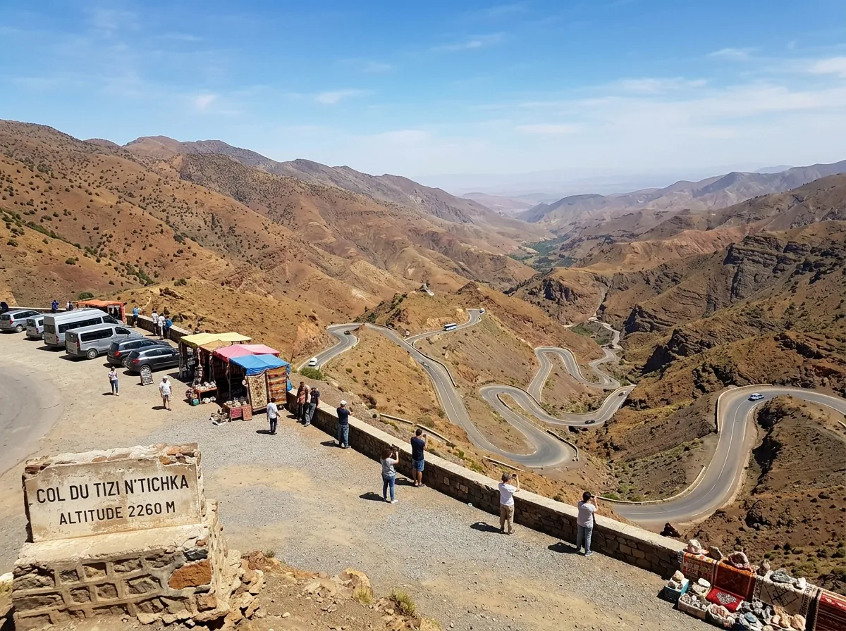
Constructed by the French Foreign Legion in 1936 along ancient caravan tracks, the Tizi n’Tichka remains the essential artery among all high atlas scenic passes. The N9 is the paved main corridor, but weather, works, rockfall, and traffic can change conditions. Check official notices for the day of travel.
🛡 Route Planning Notes: Tizi n’Tichka Passage
- Overtaking Heavily Loaded Trucks: Slow-moving commercial trucks hauling agricultural freight struggle up steep grades. Allow following traffic to pass only where safe and legal; never overtake where visibility or road markings do not permit it.
- Stopping safely: Use signed pullouts where available, secure the vehicle before leaving it, and do not stop where you obstruct traffic.
- Weather Inversions: Fog can reduce visibility quickly. Slow down as conditions require, use vehicle lights as required by local rules, and stop in a safe place if you cannot see far enough to proceed.
For travelers carrying onward toward Merzouga dunes or the Dades canyons, integrating this pass into a larger journey is essential. Review our 10-day High Atlas and Sahara road trip for a broader route-planning example.
The Ounila Valley (P1506): Telouet to Aït Benhaddou
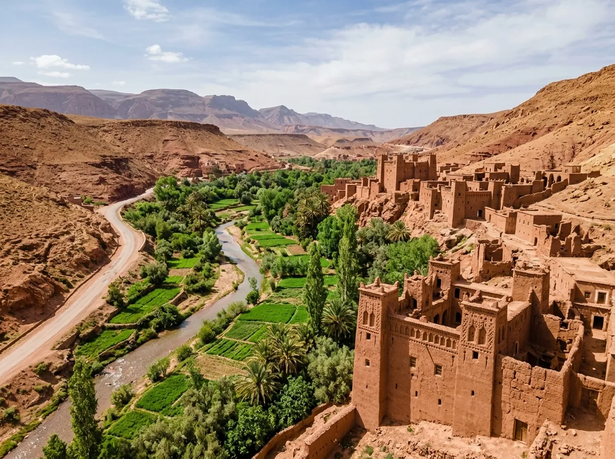
This historic detour is the most rewarding alternate route across the high atlas scenic passes. Once the private tollway of the powerful Glaoui clan controlling trans-Saharan gold caravans, the road takes you past the crumbling, tile-inlaid palace of Kasbah Telouet before descending smoothly to the UNESCO World Heritage earthen fortress of Aït Benhaddou.
🛡 Route Planning Notes: Ounila Valley
- Shoulder Edge Caution: The valley road can be narrow. Reduce speed, use a safe passing place, and do not move onto a soft or unstable shoulder to force a pass; wait for the road to clear.
- Flash Flood (Oued) Crossings: In early spring or after intense rainstorms, the Ounila river can flood low concrete crossings (radiers). Never drive through floodwater or a flooded crossing. Turn back and wait for official advice; water depth and current can be difficult to judge.
- Visiting Kasbah Telouet: Stop at Telouet before midday. Check the current entrance fee locally before entering the inner chambers decorated with exquisite zellij tilework, carved stuccowork, and painted cedar ceilings hidden behind rough clay exterior walls.
Resting overnight along the valley provides serene silence. Look for handpicked boutique kasbahs with panoramic rooftop terraces in our curated best riads in Morocco directory.
The Wild Tizi n’Test Pass (R203): Mountain Solitude
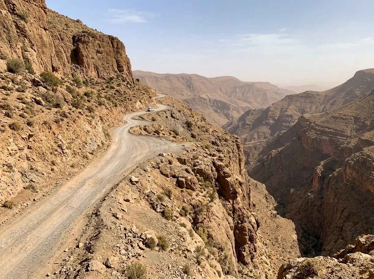
For drivers researching mountain crossings, the Tizi n’Test is one option among the high atlas scenic passes. Beginning past the trekking hub of Asni, the road skirts the historic heartland of the 12th-century Almohad Empire before plunging dramatically down the southern escarpment into the orange orchards of the Souss Valley.
🛡 Route Planning Notes: Tizi n’Test Navigation
- Narrow Road Passing: Where the road narrows, pass only at a safe place with a clear view. Do not assume priority rules beyond posted signs and local instructions, and avoid reversing toward an exposed edge.
- Post-Earthquake Reconstruction: Roadworks and route conditions can change. Check the official road-status source and local instructions before departure; do not enter a work zone or unpaved diversion unless permitted and suitable for your vehicle.
- Daylight Driving Only: For an unfamiliar mountain road, plan to travel in daylight where practical. If conditions or visibility become poor, stop at a safe place and reassess rather than pressing on.
If your route loops south toward the Atlantic coast and surf villages, examine how this mountain pass connects with our 8-day Morocco coastal itinerary for a well-rounded circuit.
Dades Gorge & Todra Canyons: The River Palmeraies
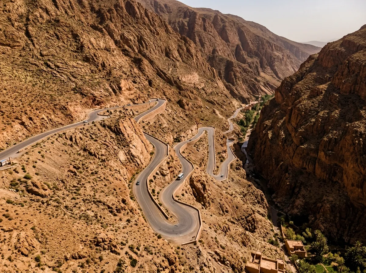
The Dades and Todra canyons are among the high atlas scenic passes. The contrast between sheer, sun-baked limestone buttresses and verdant palm groves creates one of Morocco’s most memorable landscapes.
🛡 Route Planning Notes: Dades & Todra Canyons
- Tisdrine Café Overlook: Use signed, legal stopping areas only; do not stop on a bend or obstruct traffic. Follow the vehicle manual and rental provider instructions if a dashboard warning appears.
- Pedestrian Chokepoints in Todra: The Todra Gorge road is shared with visitors and other traffic; slow down, watch for pedestrians, and follow any temporary traffic controls.
- Loop Warning (R704 to R703): The Dades–Todra connector via Agoudal is a separate remote route and may be rough or unsealed. It is not equivalent to the paved gorge roads: check current official/local status, surface, weather, and rental permissions before considering it; choose another route if uncertain.
Hikers and active travelers can pair these drives with high-elevation walking trails outlined in our Atlas day trekking and mountain biking guide. If returning to Marrakech to fly home, consult our Marrakech departure logistics guide for airport return schedules.
Mountain Driving Gear: Pack for High Passes
A practical checklist for vehicle readiness and changing mountain weather; follow the rental company’s instructions and official notices.
🚗 Road & Vehicle Kit
- Vehicle condition: Before departure, check the rental provider’s inspection checklist and confirm that the tires, lights, and required safety equipment are in serviceable condition.
- Required safety equipment: Ask the rental provider which legally required equipment is supplied, and keep it accessible in the vehicle.
- Assistance details: Save the rental company’s breakdown and roadside-assistance contact before setting off.
🩶 Thermal Attire & Protection
- Weather layers: Bring adaptable layers; mountain conditions can differ from the lowlands. Check the official forecast for your route and date.
- Sunglasses: Useful for glare on exposed sections; keep attention on the road while driving.
- Sturdy Gripped Driving Shoes: Ensures positive pedal feel and firm traction on loose gravel shoulder pullouts.
🔌 Navigation & Currency
- Offline Vector Maps (Maps.me / Organic): Mobile coverage may be unavailable. Download an offline map, but do not treat it as a source for closures or current conditions.
- Payment plan: Confirm payment methods with fuel stations, accommodation, and service providers; carry a reasonable small-cash reserve if useful to your plans.
- High-Speed 12V Dual USB Charger: Keeps navigation phones and hotspot devices fully charged on long mountain driving days.
High Atlas Road Safety & Access Questions
Planning answers based on public sources. Conditions and access can change; verify before travel.
Do I need a 4×4 vehicle to drive the High Atlas scenic passes?
A 4WD is not a blanket requirement for the paved N9 main route over Tizi n’Tichka. A roadworthy 2WD may suit paved corridors in ordinary conditions, but check current closures, works, weather, route surface, and rental permissions. Unsealed or rough side tracks are different routes and may need a suitable higher-clearance vehicle; if their condition is uncertain, do not take them.
Is the Tizi n’Tichka pass open during winter?
Do not rely on a general statement that the pass is open. Check the Ministry/CNER Inforoute service and official DGM weather-vigilance bulletins for your route and date, then follow local authority instructions. Conditions and closures can change.
How should drivers manage brake fade on steep High Atlas descents?
Avoid generic gear instructions: use the vehicle manual and rental provider guidance, obey posted signs, and drive at a speed appropriate to the conditions. If braking feels or smells abnormal, stop safely and contact roadside assistance; do not continue until advised.
Where are the critical fuel checkpoints when crossing the High Atlas?
Plan fuel stops along your chosen route and confirm current opening hours and payment methods. Do not rely on an unverified claim about a specific station’s availability; leave flexibility before remote sections.
How should I respond to a police checkpoint or speed control?
Follow posted speed limits, signs, and instructions from police or other authorities. Do not assume one speed applies to an entire corridor; road and weather conditions may require a lower speed.
Prepare Your Mountain Crossing with Local Experts
Connect with other travelers; for current closures and weather, use the official sources listed on this page.
Join Our Morocco Travel Community
Share trip-planning questions with other travelers. Facebook posts are not an official source for closures or weather alerts.
Morocco Wayfinder Digital Concierge
For current road status and weather alerts, consult the official services linked above. Concierge replies are not a substitute for instructions from local authorities or your rental provider.